Off-Road Navigation - Our Setup
Analysis paralysis when choosing a navigation setup for your rig? Check out our latest tech and review video showcasing the setup I run in my JL, featuring a deep dive...
Analysis paralysis when choosing a navigation setup for your rig? Check out our latest tech and review video showcasing the setup I run in my JL, featuring a deep dive...

I spend a lot of time (a LOT) perusing the various off-road/overland groups, pages, Jeep forums, etc and a question I see discussed frequently is, “What do you guys use for navigation/maps?” It’s a fair question, and there are a lot of opinions, videos, posts, etc out there claiming to have the best setup. I won’t claim what I am about to tell you is the “best” way, it’s just my way and I have found it to be highly effective.
If you are looking to add reliable navigation to your outdoor adventures, you’re in luck. There is a multitude of excellent apps/software/hardware available to you. From hiking to biking, off-roading to on-roading there are probably dozens of different GPS navigation capable apps, communicator/receivers, and then you can throw Starlink on the pile now. Just off the top of my head, these are some of the top apps:
AllTrails (more hiking/backpacking oriented)
Trails OffRoad (off-road/overlanding oriented trail database)
OnX (more off-road/overlanding oriented)
Gaia GPS (all in-one GPS navigation app)
The Dyrt (campsite database with maps)
iOverlander (similar to Dyrt, though not as popular)
Campendium (massive campsite database)
Avenza Maps (offline map use, GPS, Trails, Hiking, Off-road)
Those are just the few I have tried. There are so many you’ll likely suffer from analysis paralysis when trying to pick which to use. Most of them have monetized the best features via subscription, so even that isn’t a major factor anymore aside from the pricing of the subs themselves.
We’ve covered software, now let’s talk hardware. Imagine you are out in the mountains, no cellphone reception, and you need reliable GPS signal in order to utilize these apps. Assuming you are using one that let’s you download data such as maps or trails for offline use, you still need a GPS signal to fix your location. Unless, of course, you are capable of more traditional map and compass navigation, but if you are then I doubt you’d be reading this.
Enter the modern age of cellphone technology! Cellphones, those cursed, wonderful, expensive little bricks we spend a ridiculous amount of time on. In fact, you’re probably reading this in the bathroom right now. Go wash your hands and use an alcohol wipe on your phone when you are done please…yeeesh.
These days, our phones have pretty damn good GPS capabilities. Just last week, Apple announced their beta iOS 18 would add satellite messaging and location sharing via RCS messenging (Rich Communication Services) for their newest phones. I haven’t tested it yet (time to update the wife’s phone iOS), but initial reports look excellent.
In years past, I found cellphone aGPS chips were just “OK” at satellite fixing with zero cellphone reception. They weren’t as powerful as a regular GPS, relying for a lot of their accuracy and connectivity on a combo of celltower/satellite signals. Far from celltowers, I found the inaccuracy in speed and location was enough to cause me to miss turnoffs on trails, difficulty locating landmarks, ect. I eventually purchased a Garmin Glo 2 standalone GPS receiver, which I could use via bluetooth on my phone or tablet. This device, coupled with a navigation software, was extremely accurate, fast, inexpensive, and was a huge battery saver since my phone was no longer zapping it’s battery trying to find signal.
With more recent models, such as my iPhone 15, I’ve found in testing the GPS is nearly as accurate as the Garmin. These days, if I am using my phone for GPS I don’t bother with the Garmin. If I am using my iPad mini non-cellular version, I use the Garmin. This gives me redundancy as now I have two receivers in the event one fails. I like redundancy for critical equipment, so I would still highly recommend the Garmin Glo 2 since it is solidly reliable and only $120.
In the above YouTube video, I go in depth on the reasons I chose to use Trails OffRoad and Gaia GPS as my primary navigation means. If you aren’t interested in watching the video, I’ll dive into those reasons below and you can skip to the end of this blog entry, though I do suggest looking at the chart below from Reddit.
I’ll say up front that the above data collection can be mitigated on OnX by manipulating your settings on the app and your phone. I am not saying you shouldn’t use OnX strictly because of this, it’s just something I think people should know. You also should verify the accuracy of this information because data collection settings are constantly changing with newest software versions so this chart may not even be accurate anymore.
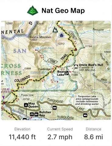
I prefer Trails OffRoad mainly because the trail info they have is extremely detailed and in an easy to use format. The descriptions are very good resources since they not only tell you basic trail information (length, type, duration, elevation, etc), but they go in depth on the waypoints for the trail. Whether it’s an obstacle, point of interest, specific intersection directions, or campsite you’ll find it listed. Typically these waypoints are accompanied by photos in the trail gallery section which is a huge help as well. You’ll also find managing agency/ranger district information which is key to knowing who to contact for up to the minute confirmation as to trail status (closed, open, fire restrictions, etc).
Another awesome feature they added a while back is the ability to upload trails to Gaia GPS. While the map in Trails OffRoad is good, they know they are primarly an information resource and an actual GPS navigator second. Gaia GPS is an incredibly powerful GPS map app and Trails OffRoad understands this. I’m a firm believer of having task specific tools when it comes to something as important as navigation so I use both of these apps together.
While Trails OffRoad may not have as many trails/roads as OnX listed, they are constantly adding routes via their scouts. These scouts go out and run trails, mapping them out as they go so you know you have real, accurate data. OnX does something similar, but they also have a ton of routes where the data is sourced from other places and so is not always accurate I have found. The reviews section on each trail listed on Trails OffRoad is also a valuable tool for verifying if a trail is open or closed, plus current trail conditions. I haven’t found OnX to be nearly as good in that situation.
Trails OffRoad does offer a free and premium version. The free version is good, but a lot of really great trails are locked behind the premium paywall. You may balk at this but I have found the best apps all do this so you’d likely be paying someone regardless. The premium version is absolutely worth it in my opinion, as it supports paying the staff that puts out this great information. Same with Gaia. Something as important as these tools is worth the investment.
As far as GPS nav apps go, Gaia is, in my opinion (and a LOT of other folks), hands down the best. Incredibly feature packed yet as simple or advanced to use as you want, you can find pretty much anything you need to on this app. The maps are excellent and the ability to add a multitude of layers such as weather, cellphone coverage, wildfires, etc is invaluable. The search feature is highly effective, though unless you have the local maps downloaded you’ll need cell service. Which brings me to my next point: always download your maps prior to your trip. Gaia allows you to do this and short of having a paper map it is critical. For off-roading/overlanding, and backpacking when I was able, Gaia has been my go-to for a long time. Couple it with the GPX file uploading via Trails OffRoad and you have a perfect match.
I could go on and on about all this but it would fill a short novel. My only suggestion is to download an assortment of apps, get the free trials of their premium version and test them out for yourself. Find what works for YOU. This is just how I do it, though I am highly confident you’d be satisfied with my method.
Questions? Input? Gripes? Drop them in the comments or message me. I’ll gladly do what I can to help!